


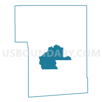
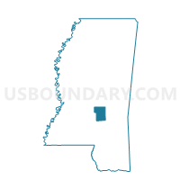
Ag Complex Voting District, Smith County, Mississippi
About
Outline

Summary
| Unique Area Identifier | 606675 |
| Name | Ag Complex Voting District |
| County | Smith County |
| State | Mississippi |
| Area (square miles) | 45.21 |
| Land Area (square miles) | 45.17 |
| Water Area (square miles) | 0.04 |
| % of Land Area | 99.91 |
| % of Water Area | 0.09 |
| Latitude of the Internal Point | 31.97262060 |
| Longtitude of the Internal Point | -89.51441750 |
Maps

Graphs
Select a template below for downloading or customizing gragh for Ag Complex Voting District, Smith County, Mississippi


Neighbors
Neighoring Voting District (by Name) Neighboring Voting District on the Map
- Center Ridge Voting District, Smith County, MS
- Mize Voting District, Smith County, MS
- North Raleigh Voting District, Smith County, MS
- Shady Grove Voting District, Smith County, MS
- Sylvarena Voting District, Smith County, MS
- West Raleigh Voting District, Smith County, MS
Top 10 Neighboring County Subdivision (by Population) Neighboring County Subdivision on the Map
- District 4, Smith County, MS (3,602)
- District 5, Smith County, MS (3,322)
- District 1, Smith County, MS (3,068)
Top 10 Neighboring Place (by Population) Neighboring Place on the Map
Top 10 Neighboring Unified School District (by Population) Neighboring Unified School District on the Map
Top 10 Neighboring State Legislative District Lower Chamber (by Population) Neighboring State Legislative District Lower Chamber on the Map
Top 10 Neighboring State Legislative District Upper Chamber (by Population) Neighboring State Legislative District Upper Chamber on the Map
Top 10 Neighboring 111th Congressional District (by Population) Neighboring 111th Congressional District on the Map
Top 10 Neighboring Census Tract (by Population) Neighboring Census Tract on the Map
- Census Tract 9502, Smith County, MS (6,086)
- Census Tract 9501, Smith County, MS (5,381)
- Census Tract 9503, Smith County, MS (5,024)